
Trekking to K2 Base Camp: A Complete Guide for Adventure Seekers
Trekking to K2 Base Camp: A Complete Guide for Adventure Seekers – if this phrase sparks excitement, you’re probably an adventure enthusiast dreaming of conquering one of the world’s most challenging treks. The journey to K2 Base Camp in northern Pakistan is the ultimate adventure, offering rugged trails, breathtaking high-altitude scenery, and a true test of endurance. In this complete guide, we’ll lay out everything you need to know – from a detailed itinerary and distances to the trek’s difficulty level and what to expect in terms of terrain, altitude, and weather conditions.
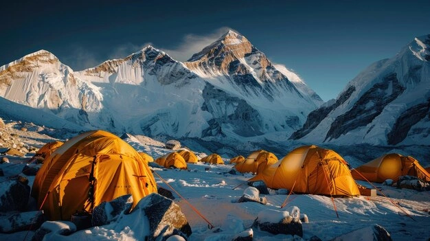
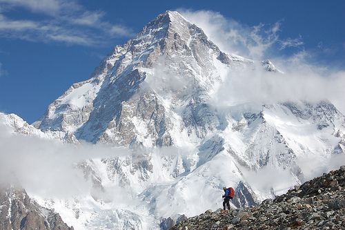
K2 Base Camp sits at roughly 5,000 m on a moraine-covered glacier with very few facilities. In this image, the brightly colored tents of a climbing expedition stand out against the backdrop of K2’s towering ice wall. Reaching this point is the culmination of the trek, offering an unforgettable view of the world’s second-highest mountain.
Trekking to K2 Base Camp: A Complete Guide for Adventure Seekers
Before lacing up your boots, let’s look at the key facts of the K2 Base Camp trek. This Trekking to K2 Base Camp: A Complete Guide for Adventure Seekers section outlines the essential details at a glance:
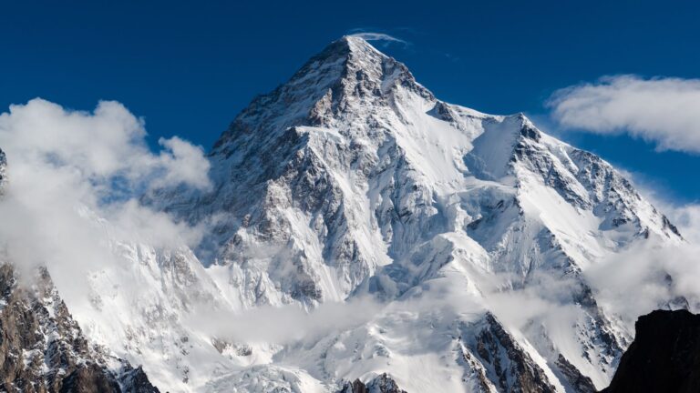
Location: Karakoram Range, Gilgit-Baltistan region, Pakistan (K2 is the world’s second-highest peak at 8,611 m).
Total Distance & Duration: ~160 km (round trip) of trekking over about 12–14 days
offtheatlas.com
(not including travel days to the trailhead).
Difficulty Level: Strenuous/Challenging – remote rugged terrain, high altitude, and long hiking days make this trek a serious undertaking
100adventurestravel.com
.
Maximum Altitude: ~5,000 m at K2 Base Camp (around 16,400 ft)
offtheatlas.com
, reached after several days of gradual ascent (Concordia camp is ~4,600 m).
Best Time to Trek: Summer (July and August are ideal
en.wikivoyage.org
; the trek is possible late June through early September. Outside this window, winter conditions and closed passes make it impractical).
Guided Trek: A licensed guide is required for foreigners (independent trekking is not allowed)
en.wikivoyage.org
, and trekking agencies arrange permits, porters, and logistics.
Day-by-Day Itinerary
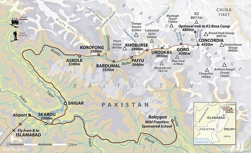
Below is a detailed day-by-day itinerary for the classic K2 Base Camp trek. This route starts with a jeep ride from Skardu to the trailhead and then leads you through the Karakoram wilderness to K2 Base Camp and back. Distances, approximate trekking times, and overnight camp altitudes are noted:

- Day 1: Skardu to Askole (3,050 m) – Your adventure begins with a bumpy 6–7 hour Jeep drive from Skardu to the village of Askole, the last settlement before the wilderness. The road winds through the Karakoram foothills along the Braldu River. At Askole, you camp overnight and meet the local trekking crew. (Distance: ~120 km by jeep; Trekking: minimal)
- Day 2: Askole to Jhola (3,200 m) – The trekking officially starts. You hike along the Braldu River on a relatively flat, rocky trail to Jhola camp. The climate is arid and can be very hot and dusty during the day, so start early. You’ll cross small streams and get the first glimpses of towering rock spires. Arrive at Jhola (also spelled Jhula) and camp by the riverside. (Distance: ~18 km; Duration: 6–7 hours trekking)
- Day 3: Jhola to Paiju (3,450 m) – Continue trekking up the valley towards Paiju. The path includes some ups and downs across barren gravel and sand. Partway, you’ll catch views of the famous Trango Towers piercing the sky. Arrive at Paiju camp by afternoon, which sits near the snout of the Baltoro Glacier. This campsite has basic facilities (toilets, wash water) compared to earlier stops. (Distance: ~20 km; Duration: 6–7 hours)
- Day 4: Rest Day at Paiju – A crucial rest and acclimatization day. Paiju is the gateway to the Baltoro Glacier, and spending an extra night here helps your body adjust to the altitude. It also allows porters to bake fresh bread and prepare for the challenging glacier travel ahead – a long-standing tradition on K2 treks. Use the day to relax, explore the area, and mentally prepare for tougher days to come.
- Day 5: Paiju to Urdukas (3,990 m) – Today the real ascent begins as you move onto the Baltoro Glacier. After about an hour of trekking from Paiju, the dusty trail gives way to the icy moraine of the glacier
offtheatlas.com
. The route is mostly a gradual incline but on rough terrain – you’ll trek 7–8 hours with a mix of rocky sections and ice. By late day, you reach Urdukas, a scenic campsite perched on a grassy slope above the glacier with spectacular views of granite peaks. (Distance: ~14 km; Duration: 7–8 hours) - Day 6: Urdukas to Goro II (4,300 m) – The trek continues up the Baltoro Glacier. Terrain here is challenging – a mix of ice, gravel, and occasional streams on the glacier surface. Expect 6–7 hours of steady trekking. You’ll pass the halfway point of the Baltoro, with mighty peaks like Masherbrum (7,821 m) coming into view. Camp at Goro II, located on the rocky glacier itself, so be prepared for a cold night on the ice. (Distance: ~12 km; Duration: 6–7 hours)
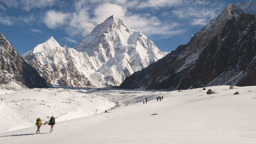
- Day 7: Goro II to Concordia (4,620 m) – A shorter but exhilarating day. After 5–6 hours of trekking, you reach Concordia, often called the “Throne Room of the Mountain Gods,” where the Baltoro and Godwin-Austen glaciers converge
offtheatlas.com
. At Concordia, you are surrounded by a 360° panorama of immense peaks – you can see K2, Broad Peak, the Gasherbrum group, and more. Many trekkers consider the view from Concordia the highlight of the journey. (Distance: ~12 km; Duration: 5–6 hours) - Day 8: Concordia to K2 Base Camp (5,000 m) and back – This is a long, tough day with an early start. You leave your camp setup at Concordia and make an out-and-back push to K2 Base Camp. Following the Godwin-Austen Glacier, it takes about 10–12 hours round-trip to cover roughly 20 km on ice and moraine. K2 Base Camp itself sits around 5,000 m
en.wikivoyage.org
, marked by the tents and prayer flags of climbing expeditions at the foot of K2’s towering face. Standing at base camp, gazing up at the world’s second-highest mountain, is an unforgettable moment. After a rest and perhaps lunch at Base Camp, you return to Concordia for the night. (Distance: ~20 km round-trip; Duration: 10–12 hours) - Day 9: Concordia to Urdukas (return) – The return journey begins, retracing your steps down the Baltoro Glacier. The hike back to Urdukas can be long but is mostly downhill or flat, which makes it quicker. You might cover the ~20 km distance in 7–8 hours. The scenery remains astounding, and descending you often gain a different perspective of the towering peaks. Camp at Urdukas again, enjoying the relative warmth and richer air at lower elevation.
- Day 10: Urdukas to Paiju – Continue the descent with a goal to reach Paiju by evening. With lighter packs and a slight descent, you may trek a bit faster than on the way up, covering ~14–16 km in 6–7 hours. By now, breathing is easier as you drop under 4,000 m. Arrive at Paiju for a final night on the glacier’s edge, relieved that the most arduous part of the trek is behind you.
- Day 11: Paiju to Jhola – A long walk back through familiar terrain. The path from Paiju to Jhola (around 20 km) will take 6–7 hours. By this stage, your legs are tired but your body is well-acclimatized and trail-hardened from many days on the move. The lower elevation and warmer air are noticeable as you return to the river valley. Reach Jhola and celebrate your last night camping on the trek.
- Day 12: Jhola to Askole – then drive to Skardu – On the final trekking day, you cover the last stretch (approximately 18 km) from Jhola back to Askole in about 6 hours. What once felt difficult on Day 2 now feels easier on the way out. At Askole, jeeps will be waiting to drive the team back to Skardu (another 6–7 hour rugged drive). Enjoy the feeling of completion as you bid farewell to the trail and return to civilization in Skardu.
Note: Some itineraries add an extra acclimatization day at Concordia or split the route differently, taking up to 14 days to reach K2 Base Camp and return
. Others may exit via the Gondogoro La Pass (5,585 m) beyond Concordia, which shortens the return by a couple of days but requires technical mountaineering skills and equipment
.
Trek Difficulty and Preparation
Trekking to K2 Base Camp is not a beginner hike – it’s often considered one of the toughest treks in the world
. The trail is remote and the days are long, typically 6–8 hours of hiking daily with few comforts. On some days you might trek up to 12 hours (for example, the base camp excursion or if crossing the Gondogoro La pass)
. This trek’s difficulty means you should be in excellent physical shape, with strong endurance and preferably some prior high-altitude trekking experience.
Expect to trek on consecutive days over rough terrain while carrying a daypack – your main gear is usually carried by porters, but you still need stamina for the daily distances. Importantly, foreign trekkers must go with an organized group or guide by Pakistani regulations
. Experienced local guides and support staff will greatly enhance safety, handle logistics, and help you navigate the challenging route.
Training beforehand is highly recommended. Cardiovascular fitness (for endurance) and leg strength (for steep climbs and descents) are crucial
. Many trekkers do long hikes with a loaded backpack to train, simulating the effort required. Mental preparation is equally key – be ready to handle fatigue and stay determined when the going gets tough. With thorough preparation, you can confidently set out trekking to K2 Base Camp: A Complete Guide for Adventure Seekers adventure and increase your chances of a safe, successful journey.
Terrain and Trail Conditions
The route to K2 Base Camp leads you through a variety of harsh terrains. In the first days, the trail winds over dirt and rock alongside the river, and it can be extremely hot under the sun. Pack animals and porters form a caravan, carrying supplies for the expedition – truly all the gear and food is hauled in on foot
.
Once on the Baltoro Glacier, the trek lives up to its reputation for rugged terrain. The photo shows a caravan of pack mules and porters carefully picking their way along a narrow ridge of the glacier, illustrating the kind of route you must navigate. Although the standard route to K2 Base Camp requires no technical climbing, the “trail” is unmarked and constantly changing as the ice shifts. You might scramble over loose moraine, skirt around crevasses, and cross glacial meltwater streams on slippery rock. Sturdy boots and trekking poles are essential for stability on this ever-changing ground.
Campsites along the Baltoro (Urdukas, Goro, Concordia, etc.) are essentially rough, rocky spots on or beside the ice. They have very limited facilities – at most a pit toilet tent and some buckets of meltwater for washing. Unlike treks in Nepal or other regions, there are no villages or tea houses along this route. The remoteness and lack of infrastructure mean you camp every night and must be self-sufficient, adding to the expedition feel of the journey.
Altitude and Acclimatization
Ascending into the high Karakoram means altitude is a major factor in this trek. You start around 3,000 m at Askole and reach over 5,000 m at base camp – an elevation where the air holds about half the oxygen of sea level. The itinerary is designed for gradual ascent, with a rest day built in (and some groups take a second rest day at Concordia) to help with acclimatization. Still, you need to be vigilant about altitude sickness. Above 3,500 m, anyone can develop Acute Mountain Sickness (AMS) if ascending too quickly. Symptoms include headache, nausea, dizziness, and fatigue.
At Concordia (4,600 m) and K2 Base Camp (~5,100 m), the altitude can certainly be felt
. Trekkers are advised to “climb high, sleep low” – for example, the day trip to base camp and back helps your body adjust. Stay hydrated, eat well, and inform your guide immediately if you feel any serious AMS symptoms. Proper acclimatization is essential
; most itineraries keep the net elevation gain to about 500 m or less per day above Paiju, which helps. If anyone shows severe symptoms, the only remedy is to descend to a lower altitude. Fortunately, the structured itinerary and support team give most people time to adapt, but always listen to your body.
Weather Conditions and Best Time to Trek
Weather in Karakoram can be extreme and unpredictable. The best window for trekking to K2 Base Camp is in the summer months of July and August
. During this period, daytime temperatures at lower elevations (e.g. Askole, Jhola) can reach 20–25°C (68–77°F), while nights are cooler. Higher up on the Baltoro Glacier, daytime temperatures are colder (often 5–15°C, 41–59°F) and nights at Concordia or Base Camp can drop well below freezing (-10°C or lower). Skies are generally clearest in mid-summer, offering incredible views, though afternoon clouds or sudden storms are possible.
The Karakoram is somewhat shielded from the South Asian monsoon, but by late August and September, increased moisture can bring more cloud cover and occasional snow at high elevations. In early season (June), you might encounter lingering snow on the trail from the previous winter, making the going slower or the glacier more covered. Be prepared for everything – intense sun (bring strong UV protection and glacier sunglasses), rain or snow, and cold winds. Weather can change rapidly in the mountains, so dressing in layers is key to staying comfortable. Outside of June–September, this route is virtually impassable due to heavy snow and extreme cold.
Final Tips for a Successful K2 Base Camp Trek
Embarking on Trekking to K2 Base Camp: A Complete Guide for Adventure Seekers is a life-changing journey. Here are some final tips to ensure you make the most of this adventure:
Go with a Reliable Outfitter: Choose a reputable trekking company or guide with K2 Base Camp experience. They’ll handle permits, logistics, and safety, allowing you to focus on the hike.
Physical Preparation: Train well in advance with long hikes, uphill climbs, and cardio workouts. The fitter you are, the more you’ll enjoy the trek.
Proper Gear: Invest in good quality gear – worn-in hiking boots, insulating layers for cold nights, sun protection for daytime, and a sleeping bag rated for -15°C (5°F) or colder. Don’t forget essentials like a first aid kit and water purification method.
Respect Altitude: Never underestimate the altitude. Acclimatize properly, heed your guide’s advice on ascent rates, and be willing to turn back or rest if symptoms of altitude sickness worsen.
Respect the Environment: The K2 region is pristine but fragile. Follow Leave No Trace principles – pack out all your trash, avoid polluting water sources, and respect wildlife. Also, value the local Balti porters and staff who are key to your journey’s success.
By following this complete guide and preparing diligently, you’ll be well on your way to turning your Trekking to K2 Base Camp: A Complete Guide for Adventure Seekers goal into reality. Standing at the foot of mighty K2 and trekking through the famed “Throne Room of the Mountain Gods” is an experience few will ever forget. This is the adventure of a lifetime – tough but tremendously rewarding. Good luck and happy trekking!
“The K2 Base Camp Trek is without a doubt one of the best treks in the world…including the world’s second-highest peak: K2.” (Off the Atlas)
K2 Base Camp trek spans ~160 km round-trip, typically 12–14 days.
“Trekking to K2 Base Camp is considered highly challenging due to the rugged terrain, high altitude, unpredictable weather…”
Best time is July–August; Pakistan requires foreign trekkers to have a guide.
Expect 6–8 hours trekking per day (some days up to 12 hours).
All trek supplies are carried in by porters and pack animals.
FAQ,s:
- How long does the K2 Base Camp trek take?
The trek takes 12–14 days round-trip, covering approximately 160 km through high-altitude terrain. - How difficult is trekking to K2 Base Camp?
It’s a challenging trek with rough glacier crossings, high altitude, and long hiking days, requiring good fitness and endurance. - What is the highest altitude on the trek?
K2 Base Camp sits at 5,000 m (16,400 ft), while Concordia, a major camp, is at 4,600 m (15,091 ft). - What is the best time to trek to K2 Base Camp?
The best trekking season is July to August, offering stable weather, clear views, and safer glacier conditions. - Do I need a guide for the K2 Base Camp trek?
Yes, foreign trekkers must have a licensed guide, as independent trekking is not allowed in this restricted region.